 Thanks to RCDR volunteers, and the cooperation of Baker County officials, we now have a single-track riding area at St. Mary’s Shoals Park (SMS). There are approximately 9 miles of an arrowed, one-way trail loop with lots of potential for on going improvements and expansion. The single track loop has been named “Tim’s Loop” in honor of our late friend Tim Miller, a long time RCDR rider/supporter/board member, and all around fine gentleman and family man.
Here are some FAQ’s to get everyone up to date:
After losing our leased Rivertown property in St. Johns County in 2018 through no fault of our own, our past RCDR president, Don Learn, and others searched long and hard for another property to lease.
Between land gobbled up by developers, property owners’ liability concerns, and the stigma of “those noisy dirt bikes”, finding acceptable land to lease was next to impossible. But we’re still looking.
After a number of Don’s conversations with Baker County officials, RCDR was given the approval by them in the summer of 2020 to lay out a one-way single track at SMS.
Mundy Murzic then took on the task as Trail Boss to get the job completed with the help of RCDR volunteers. The one way loop would be within existing 2-way established ATV trails. Although It was necessary to cross the ATV trails at various points, our plan was to utilize those ATV trails as little as possible.
Volunteer work started in July 2020 and the rideable loop, along with the separate Pee Wee track at the end of Perimeter Access Trail, was finally introduced to the club at our January 24 club party.
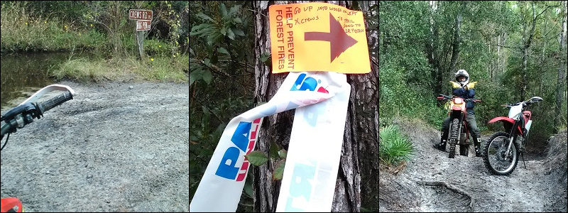
As it stands now, all of the RCDR loop is orange arrowed and designated as motorcycle “OHM” only. In other words, if you see an orange arrow anywhere on the property, it’s part of the RCDR single track network.
ATV trail and road crossings are well marked, and wrong way warnings are posted where needed.
Here’s why. The following is an excerpt taken directly from the July 2008 Florida Division of Forestry Final Report on the initial structure of the OHV side of the park:
“OHV Trails Off-highway vehicle trails will be constructed within the northwest and very northern extent of the park. Baker County officials face the decision of whether to provide for off-road motorcycles (ORMs), all-terrain vehicles (four wheeled ATVs), or both. A recent study in Ocala National Forest indicates that these two rider groups are tolerant of each other on the same trails (Albritton 2007). However, the trail conditions within the park are not conducive to ORMs. ORMs cover 25-100 trail miles per day, while ATVs typically cover 15-80 miles (Fogg 2005). GIS analyses of this property indicate that about 11-15 miles (depending on presence of hydric soils) of two-way OHV trails can be provided while ensuring protection of the park’s wetlands and providing for the other uses within the park. Therefore, ORMs would not have enough mileage for a full day of riding. Also, ORM riders prefer, and are more likely to stay on trail and obey speed limits on narrow (single track) trails (Crimmins, 2006). The existing grass trails in the park are better suited for ATVs, with widths two to three meters wide. Based on these conditions, the motorized trails in this park should be only for ATV use”.
Please take a few minutes to review the park location, fee schedule, park days and hours of operation, and rules from this link. To open, copy and paste the link in a new tab:
http://www.bakercountyfl.org/stmaryshoals.php/
This is a public park, including the single track loop put in by RCDR, and is open to the general public. So it’s our responsibility to comply with the rules of the park, especially if we are to continue to be given the privilege to use, improve, and expand the single track trail system.
As a public park, there is an admission fee and passes are required to ride there.
The best way to get passes for riding is online. To get passes, click on “Get Your Pass” on the top of the SMS home page. Once the fee is paid, you can print out the parking pass and OHV(s) pass(es). There is an electronic pay station at the site, but it’s a bit time consuming, especially on busy days, and may not always be fully operational.
Absolutely. Just remember they are 2-way, so be cautious of oncoming traffic. You’ll encounter standing water at numerous locations on the ATV trails. We have found that nearly all are passable if staying to the sides, and have hard pack bottoms.
Nevertheless, it’s best to check depths before diving in.
We’ve also found that nearly all ATV’s and SXS’s we encounter are friendly, courteous, and out to enjoy a day with family and friends just like we are.
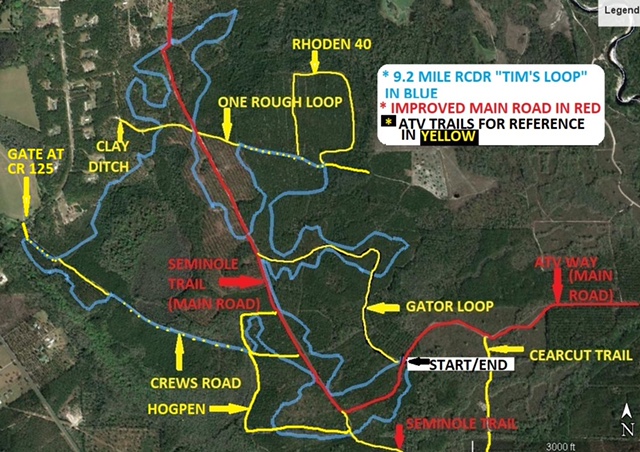
Attached is a map of the ATV side of the park. It was derived and detailed from a cell phone photo taken of the map that you’ll see at the kiosk near the OHV entrance. That map is below.
The main roads and ATV trails are well marked at the park for map reference.
The start of the RCDR single track is marked as a black star/arrow on the map.
The loop runs clockwise around the site and ends at the intersection across from the start point.
Note that the map does not include RCDR’s single track. Why? The loop is still an on-going work in progress.